God's own country, Kerala has suffered a huge blow due to devastating landslide claiming over 300 lives, vanishing roads and villages.
Within just couple of hours, three back-to-back landslides destroyed Kerala’s Wayanad. A landslide is defined as a “geological phenomenon” of “sudden movement of rock, earthen materials, and debris” down a sloped section of land. The torrential rainfall and landslide swallowed shops, vehicles, houses leaving the whole landscape totally unrecognisable. Amidst this catastrophic events, one tool that came handy in quick response and rescue operation is advanced technologies supported by Indian Space Research Organization (ISRO).
#WATCH | Kerala: Search and rescue operations continue at landslide-affected Chooralmala in Wayanad.
— ANI (@ANI) August 2, 2024
Death toll stands at 308, as per Kerala Health Minister pic.twitter.com/wzaZrps7RT
Credit - @ANI X handle
Due to destruction of bridges, analysing full extent of disaster has become a challenge. It's becoming more tougher due to nature of the terrain along with magnitude of the slide, which caused at least 6-7 kilometres of debris from the top of the slide.
Before any rescue operation, it's important to analyze the extent of damage first. Due to heavy rainfall and huge debris, the rescue team was facing lot of difficulties. Here comes India's space agency and its advanced technologies to help in disaster management.

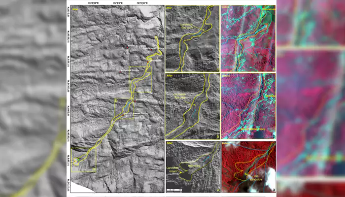
The satellite Imagery: The National Remote Sensing Center (NRSC), Hyderabad, a part of ISRO, deployed its highest resolution Cartosat-3 optical satellite along with the RISAT satellite to fully understand the damage. These two satellites are capable of taking images through thick cloud cover.
Extent of Landslide: The space agency said: “The landslide was initiated at an altitude of 1550 meters above the sea level.”
The before and after images of the landslide area showed that “about 86,000 square meters of land slipped and the debris flowed for about 8 kilometers along the Iruvaiphuzha river,” according to NRSC report.

Satellite Image showing the extent of damage and debris
Credit- @NRSC/ISRO X handle
Analyzing Extent of Debris Flow: The NRSC reports said “a major debris flow was triggered by heavy rainfall in and around the Chooralmala town of Wayanad District in Kerala state of India.”
The satellite image also displayed the “entire extent of the debris flow from crown to end of run out zone. The approximate length of the flow is 8 km.”
IBOD: As the rescue team got an overall understanding of the damage, the government will soon implement Intelligent Buried Object Detection (IBOD) technology. This will help detecting trapped people under the debris. To enhance the process, five sniffer dogs have been employed in around the debris site.
Bailey Bridge Construction: Just couple of weeks ago, Indian army developed a 70-feet long bailey bridge within 3 days in flood-hit Sikkim. The army engineers are going to do the same in Wayanad to restore connectivity.
#WATCH | Kerala: Latest visuals of the Dog squad conducting search and rescue operations in Wayanad's Chooralmala.
— ANI (@ANI) August 2, 2024
A landslide that occurred here on 30th July, claimed the lives of 308 people. pic.twitter.com/jWvqQDHWQh
Credit - @ANI X handle
ISRO’s 'Landslide Atlas of India' report, published in 2023, mentioned Wayanad region vulnerable to landslides. The report further claimed an occurrence of old landslide in the same area. During publication, ISRO chief Dr S Somanath, mentioned “it presents the overall landslide scenario in India and ... the field of landslide hazard. I am sure that the atlas will be beneficial to everyone involved in disaster management endeavors.”
Couple of months ago, researchers from the Indian Institute of Technology (IIT) Delhi published a “landslide susceptibility map.” This revealed around 60% landslide risk in Wayanad. The areas or villages swallowed by the recent landslide were marked as “very high risk zone.”
#WATCH | Kerala: Search and rescue operations continue at landslide-affected Mundakkai, Chooralmala in Wayanad.
— ANI (@ANI) August 2, 2024
Death toll stands at 308, as per Kerala Health Minister pic.twitter.com/G8thUNhWcC
Credit - @ANI X handle
One minute of nature's fury is enough to cause catastrophic results, and the vulnerable area of Kerala faced it over 4 hours! NDRF along with other agencies are currently conducting rescue operations. The whole rescue operation might take around 7-10 days.
Now, we can only pray for smooth rescue operations and rapid reconstruction work in the affected areas.