ISRO to launch its EOS-08 mission on August 16: From tracking wildfire to ocean monitoring, here’s what it will do in space
- Gurpreet
- 1 year ago
- 3 minutes read
The upcoming mission is ISRO’s third launch mission of the year, and SSLV’s last demonstration flight.
The Indian Space Research Organisation (ISRO) is all set to launch its Small Satellite Launch Vehicle (SSLV) developmental flight on August 16 instead of the earlier planned date of August 15, which coincided with Independence Day. According to the official announcement by ISRO, the launch window of (SSLV)-D3/EOS-08 Mission would be one hour starting at 9:17am, and the mission will be carried out from the Satish Dhawan Space Centre in Sriharikota.
The upcoming mission is ISRO’s third launch mission of the year, and SSLV’s last demonstration flight. The mission is aimed to determine the rocket’s reliability after which it would be shifted to the industry. “This flight completes the SSLV Development Project and enables operational missions by Indian industry and NSIL,” ISRO had shared on its website.
But what exactly is EOS-08?
The pioneering mission of EOS-08 is actually built on Isro's Microsat/IMS-1 bus, and it boasts of a range of advanced technologies. It has three main payloads: the Electro Optical Infrared Payload (EOIR), the Global Navigation Satellite System-Reflectometry payload (GNSS-R), and the SiC UV Dosimeter. With them, the satellite has enhanced capabilities in applications such as environmental monitoring, disaster management, and scientific research.
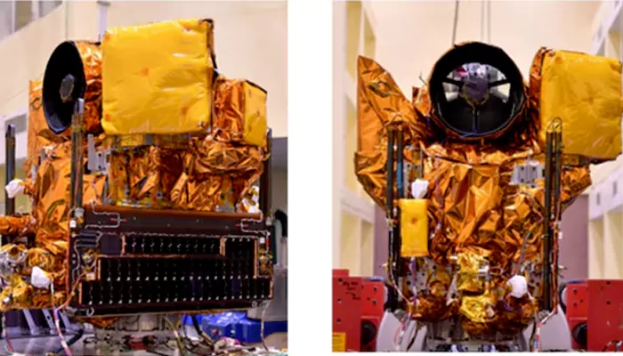
Interestingly, the EOIR payload can be utilised to capture images in both the Mid-Wave and Long-Wave infrared bands. For those caught unaware, the Mid-Wave Infrared (MWIR) and Long-Wave Infrared (LWIR) light cannot be seen with the naked eye but can be felt as heat. They are used by satellites to observe and study the Earth, and overall, detect things that are warm, like fires or warm parts of the Earth. This method can be essential in capturing wildfires, volcanic activity, and certain weather patterns, which in turn, helps in disaster management.
On the other hand, the GNSS-R payload uses the GNSS-R-based remote sensing to understand ocean surface winds apart from studying the cryosphere in the Himalayan region.
Last but not the least, the SiC UV Dosimeter will be used to monitor the UV irradiance, which in turn, can be considered as an alarm sensor for gamma radiation, and is useful in the Gaganyaan Mission. UV light, the energy coming from the sun, is invisible to our eyes but it can lead to sunburn and other skin effects.
Coming back to EOS-08, it can prove significant in developments of the satellite mainframe systems. Weighing approximately 175.5 kg, EOS-08 will operate in a low Earth orbit at an altitude of 475 km and an inclination of 37.4 degrees for about one year.